

- Abdul Rahim Said, Tom Spencer, Paul Brown and Richard Irvine Brown
- BBC fact-finding
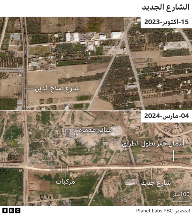
Israeli military forces have completed construction of a new road running through the northern Gaza Strip from east to west, according to satellite imagery verified by the BBC.
Israel says it is building a supply route. But some experts worry that the road could become permanent.
They also fear it will be used as a barrier to prevent Palestinians from returning to their homes in the northern Gaza Strip.
The new road begins at Gaza's border fence with Israel near Kibbutz Nahal Oz. It crosses the Gaza Strip and ends near the coast in the west.
But some analysts have expressed concern that the road appears to be part of an Israeli plan to remain in Gaza after the current military action ends.
The new road runs through northern Gaza, with the central and southern regions behind it.
Although there is a network of roads connecting east and west, the IDF's new road is the only one that runs uninterrupted throughout Gaza.
It also intersects with the Salah al-Din and al-Rasheed roads, the two main arteries that run through the region.
In February, Israeli Prime Minister Benjamin Netanyahu revealed his vision for a post-war Gaza, which includes Israel controlling security in Gaza indefinitely.
International leaders have previously warned Israel against permanently displacing Gazan Palestinians or shrinking the Gaza Strip.
The new road is likely to renew the debate over Israel's post-war strategy.
Responding to questions about the new road, the Israeli military told the BBC that they were trying to gain an "operational foothold" and facilitate the movement of troops and equipment.
What do we know about the road?
Analysis of satellite imagery by the BBC revealed that the Israeli military built portions of this road more than five kilometers long, connecting previously unconnected roads.
The initial section of the road, located east of Gaza near the Israeli border, was constructed between late October and early November last year.
But most of the new parts were created during February and early March.
The new road is wider than any typical road in Gaza, with the exception of the Salah al-Din road.
Analysis of the images also shows that buildings along the road, which appear to be warehouses, were demolished between the end of December and late January.
This includes a multi-story building.
The road runs through an area with few buildings and a low population density compared to other parts of Gaza.
It also lies beneath a temporary, winding road used by the Israeli military to move from eastern to western Gaza.
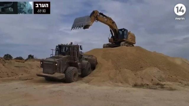
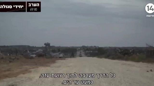
Israeli TV Channel 14 did a video report on the road in February, calling it "Highway 749." One of its reporters traveled with the IDF along parts of the road.
Road construction vehicles and excavators were seen preparing to build new sections of the road.
What are the potential uses for the road?
Analysts at Janes, a defense intelligence firm, say the type of unpaved road surface seen in the Israeli Channel 14 footage is suitable for tracked armored vehicles.
The IDF did not elaborate on such details in its statement. "As part of the ground operation, the army is using an operational road for traffic," it added.
The former head of Israel's National Security Council, General Jacob Nagel, emphasized the security considerations related to the road.
"This road will help Israel get in and out, because Israel will have full defense, security and responsibility for Gaza," he told the BBC.
He described it as "the road that separates the northern part from the southern part."
"We don't want to wait for the threat to appear," he added.
His view was shared by former IDF Major General Yaakov Amidror.
The main purpose of the new road is to "facilitate logistical and military control of the area," he added.
Justin Crump, a former British army officer who runs Sibylline, a risk intelligence company, said the new route is important.
"It certainly looks like this route is part of a long-term strategy of having at least some form of security intervention and control in the Gaza Strip," he said.
"This area separates Gaza City from southern Gaza, making it an effective line of control for monitoring or limiting movement, and it has relatively open fields of fire," Crump explained.
Khaled Elgindy, a senior fellow at the Middle East Institute in the United States, believes the road is a long-term project.
He told the BBC: "It looks like the Israeli army will stay in Gaza indefinitely."
Jundi, who is the director of the Institute's Palestine and Palestinian-Israeli Affairs Program, added: "By dividing Gaza in half, Israel will not only control what goes in and out of Gaza, it will also control movement within Gaza."
"This will likely include preventing 1.5 million displaced Palestinians in the south from returning to their homes in the north," he said.


